Manaslu Restricted Area Permits Cost (RAP, MCAP & ACAP) Breakdown
Manaslu Restricted Area Permit (RAP)
Month | Manaslu Restricted Area Permit (MRAP) |
January | $75 first 7 days + $10 per extra day |
February | $75 first 7 days + $10 per extra day |
March | $75 first 7 days + $10 per extra day |
April | $75 first 7 days + $10 per extra day |
May | $75 first 7 days + $10 per extra day |
June | $75 first 7 days + $10 per extra day |
July | $75 first 7 days + $10 per extra day |
August | $75 first 7 days + $10 per extra day |
September | $100 first 7 days + $15 per extra day |
October | $100 first 7 days + $15 per extra day |
November | $100 first 7 days + $15 per extra day |
December | $75 first 7 days + $10 per extra day |
This permit is the one that limits the region; it is checked in Jagat and again in Namrung. The fee is USD 100 for the first week in autumn, plus USD 15 a day after that. The fees drop to USD 75 for the entire winter and USD 10 each following day. In March 2027, the Department of Immigration of Nepal eliminated the rule requiring at least two trekkers, thus allowing travelers to apply independently, but we still process it through our registered agency as required.
Manaslu Conservation Area Permit
(MCAP)
The fee of NPR 3,000 (around USD 23) applies to non-SAARC citizens regardless of the length of the trek or the season. This is sufficient for using Philim and further in the conservation area of the trek.
Annapurna Conservation Area Permit (ACAP)
This is needed for the last part of the trek after Dharapani. There is a standard fee of NPR 3,000 as well.
The permits would cost around USD 175 to 260 in total, depending on the season, for a standard itinerary of 15 days. We apply for all three permits at least a week in advance, since the restricted area permits cannot be obtained at the last minute.
Best Seasons for Manaslu Circuit: Spring vs. Autumn Trail Conditions
Autumn (September to November)
We conduct more trips in autumn than in any other season due to the weather in the upper valley, rather than in the lower gorge. The monsoon ends with almost no haze in the region close to the Samagaon village in late October. Our leading trekking guides have managed to observe the Manaslu summit on no fewer than 90% of October days.
By mid-November, temperatures at the Samdo village may drop to -8 to -12 degrees Celsius, and thus we start changing participants’ sleeping bags to warmer ones. The moraine near the Larkya Pass is the driest here, consisting of loose rocks instead of dense snow.
Unfortunately, accommodation services in the village of Larkya are not always enough, so we often need to accommodate our group in several lodges during peak weekends in late October.
Spring (March to May)
Spring sees milder temperatures than the winter months, and a less intense gorge. The forest of rhododendrons between Machka Khola and Namrung is awash with deep red blooms in April, a stretch of trail that takes on a sickly green hue in autumn. It's a section of the trek that our returning clients often request we time their visit to, in order to witness the floral display.
The Larkya La Pass has less snow in early April, making for a more challenging, if not slower, trek than later in the season, when the trails firm up to be more consistent, if somewhat easier than their autumn counterparts.
Afternoons see a cloud build-up earlier in the spring months, sometimes as early as 9 am in Samagaun, meaning we often have to time our ascents to the Larkya Phedi even earlier than in autumn to see the summit before the wall of cloud arrives. Agricultural burning in the lower valleys can sometimes cause reduced visibility of distant peaks in April, usually cleared by the second week of May.
Trail Conditions and Terrain Breakdown That You Can Expect Daily
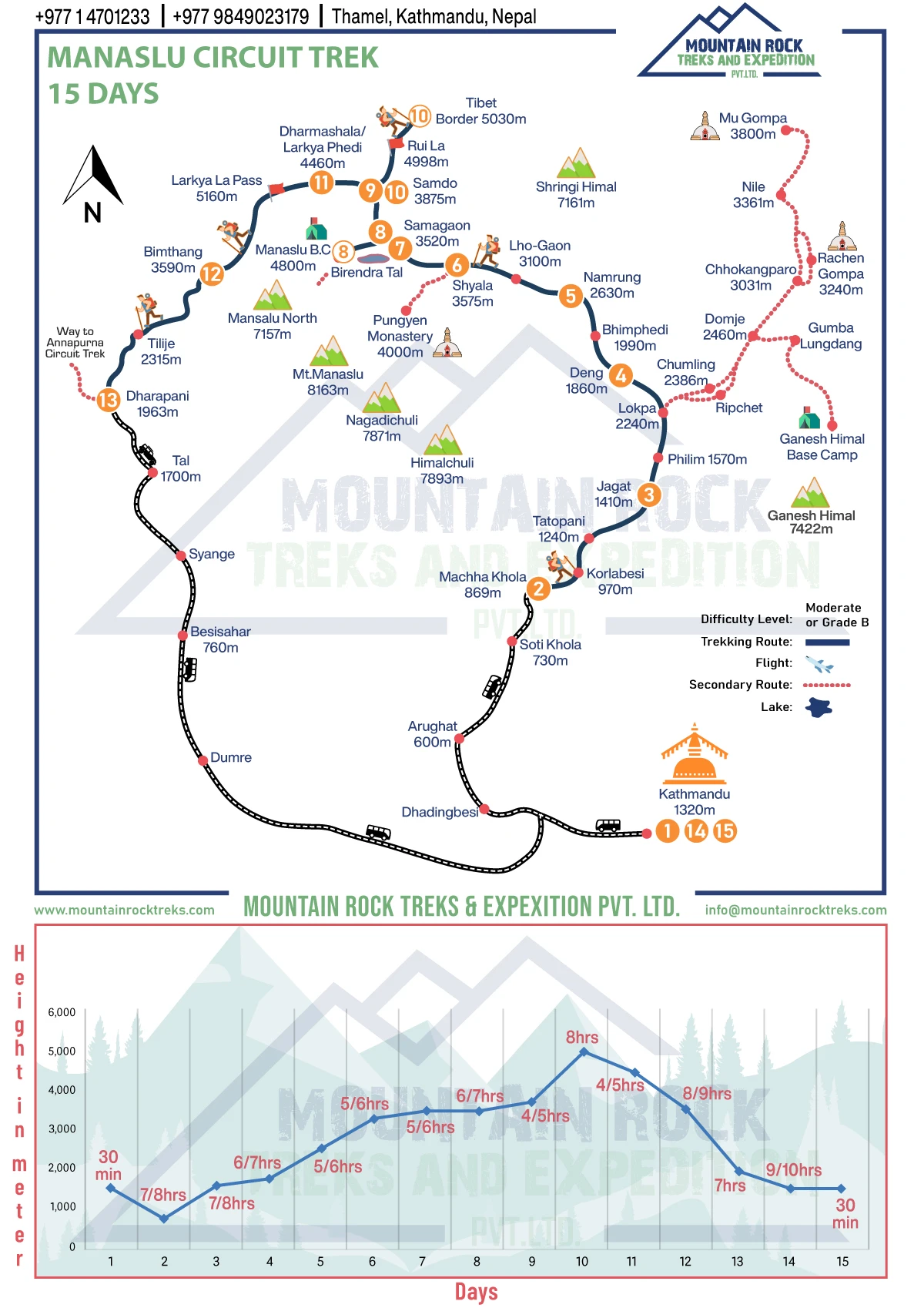
- Machha Khola to Jagat (Days 2-3): This stretch of gravel road riverside features 6 to 8 suspension bridge crossings spanning the Budhi Gandaki, many rebuilt after damage from the 2023 monsoon - something our guides witnessed with their own eyes. It's hot, subtropical, and if you do get hit by any rain, you will spend all your time negotiating an inevitably slick and unavoidable slippery part of the river road, a spot known to more of our clients as their downfall than any section of trail anywhere. This is another common pitfall – the relative lack of danger in many low-elevation trails creates something of a false sense of security for walkers who know that up high, they absolutely need to pay attention at every turn and every step.
- Jagat to Namrung (Days 4-5): The trek through the gorge sometimes cuts into a rocky cliff with sheer drops, and there will be occasional points that narrow or widen depending on how far up the valley it is. Landslide-danger sections near Deng change annually; sometimes changing from week to week, with the guides taking a different section that locals may or may not give us information about beforehand, depending on the lodge keeper they happen to consult that specific week.
- Namrung to Samagaon (Day 6): The trail emerges from the forests into alpine scrub, while the terrain changes a little to gravel and stone steps (nothing to write home about). What's really different is exposure. At Lho, the winds suddenly start to howl around you once you are above the treeline. Side-trail routes during acclimate days (Day 7-9) into both Base Camp and Pungyen Gompa sites are not so much defined trails as loose scree running above 4000 meters without being at all clearly marked for clients' eyes, which is why we send a Sherpa back with our clients as opposed to allowing them to walk themselves.
- Samdo to Larkya Phedi (Day 10): Right here is the start of the glacial moraine landscape. Grey rocks with barely a trace of green, and you'll leave your walking poles behind once we get any higher than here.
- Larkya Phedi to Bimthang via Larkya La (Day 11): For the first two hours, it's darkness plus frozen moraine. Once we reach the pass, we'll be trekking on hard-packed snow or completely exposed bare rock (depending on the season), after which you'll start one of the circuit's toughest days: a descent, down-sloping gravel over almost 1500m.
- Bimthang to Dharapani (Day 12): And we're back to forest trails: switchbacks, rhododendron, and pine underfoot, almost a pleasant relief from a day and a half of ice and granite.
How Difficult Is the Manaslu Circuit Trek?
In our view, this trek is strenuous, instead of the "moderate to strenuous" terminology used by some travel agencies to make their booking attractive. The tough parts are concentrated in three sections of the trail: the bare gorge section between Jagat and Deng; the six nights spent at an altitude higher than 3500 m; and the Larkya La crossing itself, which is the 5106 m high pass of the trek and takes about 8 to 9 hours to cross, climbing 570 m and descending almost 1500 m until reaching Bimthan.
What Actually Makes It Hard
- Sustained altitude exposure longer than Everest Base Camp, with no conveniently located yak ride back if you pass Namrung.
- A technical pass day that mixes sub-zero pre-dawn temperatures, slippery moraine, and a steep and tiring descent on the same legs you used to get up.
- Truly basic lodging options beyond Samagaon, sometimes with few rooms available at the Larkya Phedi, meaning no room to wait if the weather turns bad.
- Getting isolated in a restricted area with no option but to call a helicopter for evacuation, several days away, rather than a short walk to a bigger village.
Difficulty by Section
Section | Terrain | Altitude Gain | Our Difficulty Rating |
Machha Khola to Jagat | Riverbank, bridges | Moderate | Easy to moderate |
Jagat to Namrung | Gorge, exposed drops | Steady | Moderate |
Namrung to Samagaon | Alpine scrub | Steep | Moderate to hard |
Samagaon to Samdo | Glacial approach | Moderate | Hard |
Larkya Phedi to Bimthang | Moraine, snow, scree | 570m up, 1500m down | Hardest day, technical |
Who This Actually Suits
Fitness is less important than pacing discipline here; we've seen fit runners get stopped cold at Samdo while their slower, steadier trekking companions never had a problem surmounting Larkya La, due to altitude and hydration issues.
Accommodation on the Manaslu Circuit Trail
It is a teahouse trek from beginning to end, with no camping necessary (contrary to what some might tell you given the remoteness of the area) despite the drop-off in elevation above Namrung. We personally stay in the lodges we book for you, and do not take a broker's word for the condition of any given room, rotating out of places that cut corners.
Kathmandu Hotels Before and After
We offer our guests a package deal that includes a three-star hotel in Kathmandu. For clients who prefer to stay at hotels closer to the Hyatt or other five-star chain properties, a difference in price is introduced so that that difference is not incorporated into a low rate.
Soti Khola and Machha Khola
In Soti Khola, we prefer Fulbari Guest House and Satkar Guest House to the Green Valley and Tsum Valley properties nearby mainly due to the fact that the linens in the former two guest houses held up significantly better in our last visit. The options in Machha Khola, which include Tsum Valley Guest House, Larkey Guest House, and Everest Guest House, as well as those in Soti Khola, do offer wi-fi, though we do not guarantee that it will work every night.
Jagat
Jagat Guest House and Manaslu Santi Guest House are our default establishments, as both of them are equipped with satellite phone communications when cell service weakens, which is a crucial point that is not taken seriously enough by trekkers at this stage of trekking in restricted areas.
Deng
Windy Valley Guest House and New Manaslu Guest House offer wifi, however, hot water is out of service. This is the first major decline in service quality we inform tourists about.
Namrung
Namrung Thakali Guest House and Nubri Four Seasons Hotel have hot showers and wifi despite their elevation, and it is reasonable to think that this is the last comfortable place on the way.
Lho and Samagaon
Majestic Manaslu Guest House and Tashi Dalek Guest House in Lho and Mount Manaslu Guest House or Peace Heaven Guest House in Samagaon offer satellite phones and hot showers; however, it is better to reserve rooms in Samagaon beforehand because climbers and trekkers going to the base camp can get the limited number of available beds during climbing season.
Samdo and Larkya Phedi
In Samdo, the Yak Hotel and the Jambala Guest House lower their prices to wifi only, with no hot showers. Past that, at the Dharamsala-style shelters of Larkya Phedi, the Jambala and the Larkey Guest House provide only minimal assistance and a bed, with no wifi and no hot water, and sometimes only six rooms overall in the entire settlement.
What Accommodation Actually Costs
The price for the peak season is three to five US dollars per night in the lower gorge, and seven to ten USD higher up and past Samagaon. The off-season price is two to three USD lower down and five to seven USD higher up. Rooms are cheap because most of the lodging’s income is generated through food, not through beds, which is worth keeping in mind when considering how much to pay for a meal at the guest house.
Rooms, Bathrooms, and Basic Comforts in Teahouses
Rooms
Rooms are generally shared between two guests and have two single beds with thin foam mattresses. The walls are made of wood, and insulation is minimal. Single rooms exist below Namrung but tend to become less reliable beyond Samagaon, when hotels might only offer a few twin-bedded rooms regardless of the number of travelers.
Bedding, Blankets, and Sleeping Bags
Hotels provide just a basic blanket, which might not be sufficient if someone is above 3500m. Every traveler is given a -15°C sleeping bag, which is included in the package, since relying just on hotel bedding leads to having cold nights in the end, e.g. in Samdo and Larkya Phedi places to stay.
Attached and Shared Bathroom Facilities
Rooms with a bathroom are available only below Samagaon, and their amenities are rather simple – just a toilet and a bucket with a tap. Any accommodation in higher areas has shared bathrooms on the street or in a hallway.
Hot Showers and Personal Hygiene
Hot showers (electric or gas-powered) cost between NPR 300 and NPR 500 and become unavailable with each next stop, starting from Samdo and Larkya Phedi. Therefore, we recommend using wet wipes for the last three to four night stays.
Electricity, Charging, and Mobile Connectivity
Charging is done via solar power from the lodge, but it is a bit pricey (NPR 200-400 per device per charge) and only cash. NTC signal is generally good until Samagaon, but then disappears entirely at Samdo and Larkya Phedi.
Wi-Fi Availability at Manaslu Teahouses
There is sometimes wi-fi downstairs in the lodge (but it can be slow), while after Samagaon it is completely unavailable. This is a big difference compared to the teahouses in the Everest region, where wi-fi is available for a small fee almost everywhere.
Dining Rooms and Common Areas
The only warm place to be in most of the lodges is the dining hall, where there is a central wood/yak-dung stove that people gather around, chatting after dark. This is where most of the socializing during the trek takes place, as the bedrooms are generally too cold to sit around in.
Meals on the Manaslu Circuit Trek
Meals Included in the Manaslu Circuit Trek Package
In the Machha Khola to Bimthang trekking journey, breakfast, lunch, and dinner are served. All the meals are freshly prepared at local teahouses, while all the meals in Kathmandu and the trip back to Kathmandu are excluded because of more choices for restaurants there.
Breakfast, Lunch, and Dinner on the Trail
Breakfast is usually a mixture of porridge, eggs, toast, and Tibetan bread served with coffee or tea. Lunch is served on the way at the teahouse around midday, consisting of noodles, fried rice, or dal bhat. Dinner is the heaviest meal and consists of dal bhat, and the dish is served with plenty of refills, which is the choice of the guides for tomorrow's journey.
Local Nepali and Tibetan-Style Food Options
Below Namrung, menus are more Nepali, featuring dishes such as dal bhat (lentil soup and steamed rice) or momos (steamed dumplings). Further up the trail towards Samdo and the old trade route, we start to see more Tibetan dishes, namely thukpa (noodle soup), tsampa (a porridge made from roasted barley), and Tibetan bread, as Tibetan Buddhism more influences the region.
Meals at Higher Altitudes
Menus shrink after Samagaon, as there are no roads and the availability of fresh produce diminishes. We also do not allow meat to be ordered above Samagaon, as the supply chain is too far and it is likely that the meat has been sitting in a freezer for a very long time. Dal bhat, potatoes, and instant noodles will get you through the final stretch to Everest Base Camp.
Drinking Water and Refreshment Costs on the Manaslu Circuit
Costs rise steadily and are significantly higher than in the Everest region during this period, as most goods are hauled up on mules and donkeys, while the mix of yak and helicopter resupply is less prevalent. Tea costs USD 2.5 to 4, coffee USD 3 to 5, 600 ml beer USD 5 to 8 and water or soda USD 2 to 5 (bottled), with prices climbing towards the top end of this range the higher you go towards Samdo.
At lower altitudes, bottled water costs approximately NPR 200 (about USD 2), while at higher altitudes, it costs NPR 400 (approximately USD 4). This is the main reason why many seasoned trekkers are against using bottled water. You should know about the availability of free water purification tablets, which you can ask for when you check your gear at our office in Kathmandu. Water from natural sources along the trekking route is considered clean, but it can still be boiled and treated safely.
A sheet of instructions about the amount of water to bring with you on the hike states that you need to carry one or two liters of water at a time while being on the trail because there are many water points during the trek (about every hour or two of walk). In total, during your day you should aim to drink four to six liters of water. You should have both hot and cold water bottles with you because you will be drinking a lot of garlic soup and tea after Samagaon.
Manaslu Circuit Trek: Altitude Sickness Management
Why This Route Carries Real Risk
Six straight nights of sleeping over 3,500 meters culminated in traversing the highest point of this trek, the 5,106-meter-high Larkya La. In our Everest Base Camp itinerary, your exposure to altitude and altitude risk significantly increases on the Seven Passes.
And for clients of variable fitness, including a couple of very fit marathoners that we've seen struggle through a day or two around Samdo while less fitness-attuned trekkers have traversed the Larkya La with relative ease, the risk is about as uniform as altitude gain can get.
We educate our clients on this before departing on all our treks from Annapurna to the Langtang, rather than allow them to believe their physical conditioning will automatically offer them protection.
Our Monitoring Protocol
- Guides carry pulse oximeters and check oxygen saturation levels on a daily basis from Namrung, even if climbers don't complain
- If it's under 85 percent and the climber is experiencing symptoms, we slow their pace or stop them, rather than asking a majority vote on whether to continue or not
- We've kept a client at Samagaon for an additional day, instead of sending them on to Samdo on a scheduled day, even in the middle of the climbing season
Fixed Acclimatization Points
Both acclimatization days are part of the normal travel schedule; Samagaon offers one acclimatization day with the option of walking to Base Camp or Pungyen Gompa, and one at Samdo, where we visit the old Tibet trading route.
What We Watch For
Acute mountain sickness symptoms such as headaches, nausea, and loss of appetite are taken seriously and are treated as early warning signs. Confusion, loss of coordination, and breathlessness at rest require immediate action.
Evacuation Readiness
The guides use satellite communications devices as soon as we leave the area of mobile telephone cover, which occurs around Samdo. We check the client’s travel insurance to ensure that it has adequate coverage for helicopter evacuation in case it is required, as standard policies often do not give adequate coverage, and in previous years there have been cases where clients had to be evacuated from Samdo owing to insurance shortcomings.
How to Reach the Trailhead of the Manaslu Circuit Trek
From Kathmandu to Soti Khola
We do not provide flight service to our clients, and this confuses new trekkers in restricted areas. The trip from Kathmandu to Soti Khola is approximately 150 km and takes 7 to 8 hours, not because the distance is long but because the drive becomes rugged and bumpy after Arughat. We start the journey at 6 am so that we can finish the toughest sections of road before the local buses and jeeps catch up along the road on their way to Soti Khola.
Why We Refuse Shared Buses on This Leg
Some clients prefer using public bus services and then taking local jeep transfers from Arughat, thus costing clients around USD 15 less per person. Here, we do not approve of this alternative. Given how crowded this road is, shared means of transportation can lead to delays, as there will be many stops along the way. We will not risk the safety of our clients to save money.
Road Conditions We Actually Track
The same drivers who have worked with us for several years, instead of the new drivers available at the time, make sure that landslide activity reports are received from Arughat district. It should be noted that we had to spend the night in the village instead of risking the drive after dusk through the potentially dangerous area.
Where the Trek and Permits Actually Begin
Soti Khola is the main starting point of the trek,. Still, it is also possible to arrive at Machha Khola after an additional 2 to 3 hours of walking once the overall situation improves and a departure on that day is confirmed. Anyway, the permit is checked only at Jagat a day ahead of time; you may travel the road before that since the actual entry into the Restricted Area of Manaslu starts on foot.
Suspension Bridge Crossings on the Manaslu Circuit: Safety and Guidance
- There are between 6 and 8 major crossings over the Budhi Gandaki in the section between Machha Khola and Jagat – the steel wire bridges sway considerably beneath us. Some were rebuilt after being destroyed during the monsoon period, and our guides have seen the incidents happen with their own eyes.
- One person at a time is obligatory. We enforce this rule quite strictly as the test weight of the bridges has not been defined according to the modern norms of engineering.
- Wet planks will get extremely slippery, and the guides lower the pace in this area so no one crosses at high speed.
- Mules always have priority when moving on narrow trestle bridges, so we prefer to wait until the trains pass rather than try to avoid them while crossing.
- According to the experts, the higher the elevation, the greater the impact of the wind, so the bridge sections between Namrung and above sway more strongly than those in the lower gorge area, which is one of the mistakes made by those trekking in the restricted areas for the first time.
- The trekking poles were folded, not pinned into the bridge footway, as some of the clients happen to trip on poles situated between the boards rather than being affected by the swaying.
- Due to the fact that some old bridges after the Deng Pass have no handrails but only wires, our guides walk close to those clients hesitating instead of demonstrating confidence.
- Photography takes place not on the bridge but away from it, as we have already seen other trekking groups stopping on the way to take photos and therefore blocking the traffic behind them.
Local Trekking Guide and Porter Information
Guide-to-Client Ratio
At Manaslu, we assign one guide for every six trekkers so that we do not end up with one guide struggling to manage a large number of trekkers, since the process of altitude monitoring can be successful only when a guide is able to speak to the trekkers daily and know how they are doing physically and not just look around and count the heads.
Who Leads Our Manaslu Groups
Ram Bhatta is our leader on the route. Ram was born in the Gorkha district and practically grew up at the foothills of the Manaslu range. Therefore, when the clients start calling him “the mountain goat” after the first few days on the trek, it truly makes sense. Ram’s understanding of the trail and his knowledge about timing the Larkya La crossing to keep ahead of the dreaded morning winds do not come from any books and manuals but from life experience.
Licensing and Training
All our guides are licensed under the Nepal Ministry of Tourism, and they are also certified in First-Aid under the Nepal Red Cross Society, as well as experienced in operating in restricted areas. This is an important safety prerequisite, as Manaslu requires permit formalities and checkpoints, not found on popular routes.
Porter Weight Limits
According to the Porter Welfare guidelines of Nepal, porters can only carry up to 20 to 25 kgs which is generally divided between two duffels for two clients, weighing about 10 to 12 kgs each. In most cases, nosotros weigh the bags beforehand but make sure to avoid carrying heavy bags since that could lead to injuries more associated with the porters rather than the travelers.
Local Hiring and Insurance
We always prefer to recruit porters from local places so that they can be found mostly in villages along the way, and we also get insurance for the travel attendants on the Manaslu trekking trip, something which some budget companies do not take care of.